Essayer OR - Gratuit
Intro to Aerial Mapping
RotorDrone
|December/ January 2021
Tools that make maximize your bird’s-eye-view

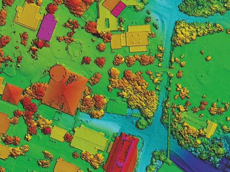
Aerial maps can be created from a collection of aerial photos that are stitched together with computer software. A batch of overlapping, vertical aerial photos is processed and referenced with their GPS position. The processed aerial maps are used in many industries such as agriculture, emergency response, construction, mining, and environmental monitoring. When they’re made at regular intervals, aerial maps can document changes to a specific area in a process known as “change detection.” Multiple aerial maps, collected over time, can be compared with current and past images to detect patterns that are not visible from the ground. Change detection is essential for many applications such as monitoring snowpack, vegetation density, and storm erosion. While several companies have developed mapping solutions, this article will focus on three that are compatible with the most common line of DJI drones: Maps Made Easy, DroneDeploy, and Pix4D.
USING THE SOFTWARE

Cette histoire est tirée de l'édition December/ January 2021 de RotorDrone.
Abonnez-vous à Magzter GOLD pour accéder à des milliers d'histoires premium sélectionnées et à plus de 9 000 magazines et journaux.
Déjà abonné ? Se connecter
PLUS D'HISTOIRES DE RotorDrone

RotorDrone
Windracers Mail Delivery
With its partner Windracers Ltd., Royal Mail has become the first UK parcel carrier to deliver mail to a UK island in a 70-mile, beyond-line-of-sight, autonomous flight to the Scilly Isles. Tasked to better connect the islands’ remote communities, a consortium including Royal Mail, Windracers Ltd., DronePrep, University of Southampton, Excalibur Healthcare Services, and Consortiq Limited is funded by UK Research and Innovation.
1 mins
August/ September 2021

RotorDrone
Counting Penguins
Counting penguins is harder than it sounds. With freezing rain, snow, and chilling winds that limit the flight windows for the surveys, it takes scientists using three full days to map the location of 300,000 nesting pairs of Adélie penguins on Antarctica’s Cape Crozier.
2 mins
August/ September 2021

RotorDrone
A Drone Double Play
Beach cleanup and a historic bridge
13 mins
August/ September 2021

RotorDrone
Understanding Aviation Sectional Charts
Signs and symbols every remote pilot needs to know
10 mins
August/ September 2021

RotorDrone
10 TOP JOBS
Fields where drones are taking off!
17 mins
August/ September 2021

RotorDrone
AUTONOMOUS RESUPPLY IN A CONGESTED BATTLESPACE
Can autonomous drones deliver supplies to troops in an active firefight? DroneUp recently partnered with a North Atlantic Treaty Organization (NATO) Allied Command Transformation (ACT) Joint Force Development (JFD) exercise to find out.
3 mins
February/ March 2021

RotorDrone
IMPROVE YOUR DRONE PHOTOGRAPHY
10 must-know Lightroom tips
12 mins
February/ March 2021
RotorDrone
UAS TRAFFIC MANAGEMENT The Key to the Future of Drones
In 2012, Congress passed the FAA Modernization and Reform Act, which established a deadline for the agency: achieve full integration of drones into the airspace by 2015. As the calendar rolls over into 2021, this begs an obvious question: “Are we there yet?”
28 mins
February/ March 2021
RotorDrone
FLYING FOR A LIVING
A professional UAS operator on what it takes to be successful
6 mins
February/ March 2021
RotorDrone
ON THE WING
This bird-like drone is incredibly agile and efficient
2 mins
February/ March 2021
Translate
Change font size