
استمتع بـUnlimited مع Magzter GOLD
احصل على وصول غير محدود إلى أكثر من 9000 مجلة وصحيفة وقصة مميزة مقابل
Drone U's Accident-Mapping Class
January/ February 2019
|RotorDrone
ANYONE FAMILIAR WITH DRONE mapping may understand the long list of complex nuances of acquiring and processing 3D models using aerial photography.

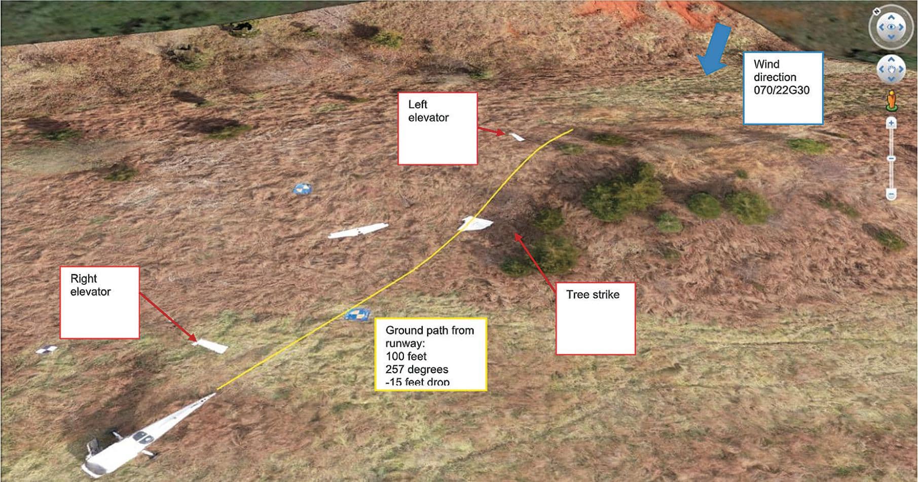
Drone mapping may be complex, but accident-scene reconstruction using drone mapping adds an entirely new level of intricacy. With crash-scene reconstruction, accuracy must be exact when court decisions depend on the data. Drone U may have made learning easier by gamifying the drone training experience.
While pilots may make drone mapping flights look easy, data processing usually accounts for 80 percent of the time necessary to complete a drone map. It follows, then, that learning how to process aerial images to create drone maps accounts for a large majority of training pilots. This is where most training falls short. Typically, drone-training programs primarily focus on processing drone images to create maps without teaching students a practical acquisition strategy to acquire the data necessary to process these maps. To help solve this challenge, Drone U partnered with Pix4D to offer an accident-scene reconstruction class where drones were used to map plane and helicopter crashes. The training took place at the National Transportation Safety Board (NTSB) training academy, and students had the unique opportunity to fly and map a Cessna plane crash and a helicopter crash. Students completed three practical missions that focus on unique aspects of drone mapping acquisition strategy.

هذه القصة من طبعة January/ February 2019 من RotorDrone.
اشترك في Magzter GOLD للوصول إلى آلاف القصص المتميزة المنسقة، وأكثر من 9000 مجلة وصحيفة.
هل أنت مشترك بالفعل؟ تسجيل الدخول
المزيد من القصص من RotorDrone

RotorDrone
Windracers Mail Delivery
With its partner Windracers Ltd., Royal Mail has become the first UK parcel carrier to deliver mail to a UK island in a 70-mile, beyond-line-of-sight, autonomous flight to the Scilly Isles. Tasked to better connect the islands’ remote communities, a consortium including Royal Mail, Windracers Ltd., DronePrep, University of Southampton, Excalibur Healthcare Services, and Consortiq Limited is funded by UK Research and Innovation.
1 mins
August/ September 2021

RotorDrone
Counting Penguins
Counting penguins is harder than it sounds. With freezing rain, snow, and chilling winds that limit the flight windows for the surveys, it takes scientists using three full days to map the location of 300,000 nesting pairs of Adélie penguins on Antarctica’s Cape Crozier.
2 mins
August/ September 2021

RotorDrone
A Drone Double Play
Beach cleanup and a historic bridge
13 mins
August/ September 2021

RotorDrone
Understanding Aviation Sectional Charts
Signs and symbols every remote pilot needs to know
10 mins
August/ September 2021

RotorDrone
10 TOP JOBS
Fields where drones are taking off!
17 mins
August/ September 2021

RotorDrone
AUTONOMOUS RESUPPLY IN A CONGESTED BATTLESPACE
Can autonomous drones deliver supplies to troops in an active firefight? DroneUp recently partnered with a North Atlantic Treaty Organization (NATO) Allied Command Transformation (ACT) Joint Force Development (JFD) exercise to find out.
3 mins
February/ March 2021

RotorDrone
IMPROVE YOUR DRONE PHOTOGRAPHY
10 must-know Lightroom tips
12 mins
February/ March 2021
RotorDrone
UAS TRAFFIC MANAGEMENT The Key to the Future of Drones
In 2012, Congress passed the FAA Modernization and Reform Act, which established a deadline for the agency: achieve full integration of drones into the airspace by 2015. As the calendar rolls over into 2021, this begs an obvious question: “Are we there yet?”
28 mins
February/ March 2021
RotorDrone
FLYING FOR A LIVING
A professional UAS operator on what it takes to be successful
6 mins
February/ March 2021
RotorDrone
ON THE WING
This bird-like drone is incredibly agile and efficient
2 mins
February/ March 2021
Translate
Change font size