
MODERN TECHNOLOGY CONTINUES to transform our lives, and the fishing world is no exception. From sonars, stabilizers and power systems to social media and satellite phones, the paradigms are endless. But some of the most useful and accessible of these advancements are the satellite-data services that specialize in consolidating ocean conditions into a near-real-time, practical form for fishermen.
To start, it's important to understand how this data becomes available. I spoke with Mark Hess, director of operations of SeaView Fishing, and Matthew Upton, president of ROFFS, to learn how these two industry leaders break down this data, and how all fishermen can benefit from services like these.
While it seems fishermen have no problem spending money to find fish, we still haven't launched our own satellites into space, so the information that these companies use comes from data derived from National Oceanic and Atmospheric Administration and NASA satellites, as well as other space agencies and universities. All of the various fishing services are essentially using the same data, with the algorithms and breakdown of how this information is processed and interpreted being the difference between them.
This story is from the October 2022 edition of Marlin.
Start your 7-day Magzter GOLD free trial to access thousands of curated premium stories, and 8,500+ magazines and newspapers.
Already a subscriber ? Sign In
This story is from the October 2022 edition of Marlin.
Start your 7-day Magzter GOLD free trial to access thousands of curated premium stories, and 8,500+ magazines and newspapers.
Already a subscriber? Sign In

TOURNAMENT SEASON IS HERE
Time to gear up for your favorite events
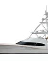
BAYLISS 76
The second project for a current Bayliss owner is in the initial phases of construction at Bayliss Boatworks in Wanchese, North Carolina.

POINTS OF NEGOTIATION IN FOREIGN CONSTRUCTION CONTRACTS
Be sure to understand the details when building a vessel in another country
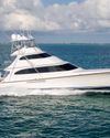
MERRITT 88
A unique skybridge design from a world-famous boatbuilder

BIG BLUES AND BIG MONEY IN BERMUDA TRIPLE CROWN
Who will take home the coveted title of champion team this summer?

INSTRUCTOR SPOTLIGHT: BRAD GOODRICH & CHARLES PERRY
New school meets old school when it comes to proper angling training
RETURN OF DOUBLE HEADER
The rebirth of a classic sport-fisher amid one of the most prolific destinations for big blue marlin

THE SCIENCE OF FADS
An in-depth look at what makes these fish attractors so effective

ARMED AND DANGEROUS
In a day when piracy on the high seas still exists, traveling with firearms on board remains not only a personal choice but a safety issue as well
JIMMY'S DREAM
The planning and design of a new Merritt lost shaker of salt included catamaran,